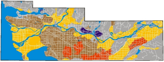
Flood Hazard
This map provides a generalized
interpretation of hazard based on the distribution of modern
flood deposits. Low-lying areas adjacent to
rivers and the sea shore are coloured red. These areas are
underlain by modern flood and coastal storm deposits. The red
zone includes
floodplains of the Fraser River and its tributaries, and gently
sloping fans at the mouths of the Chilliwack, Coquitlam, Seymour,
Capilano
rivers. This zone also includes poorly drained areas in the
Nicomekl and Serpentine river valleys. Although most of these
areas have been
dyked to protect people and property, they are still at risk
from rare, exceptionally large river floods. Low-lying shorelines
exposed
to waves and strong winds can also be flooded during exceptional
storms if the winds push water inland. Localized flooding can
occur at the front of the Fraser delta when a storm or high tide
coincides
with a Fraser River flood. In both the red and black zones
on the map, small streams, which are not shown at this scale,
can also overflow
their banks. These relatively small floods are triggered by
heavy rainstorms.

 Moderate
to High (modern lowland sediments) Moderate
to High (modern lowland sediments)
 Low -
except adjacent to small streams (uplands and mountains) Low -
except adjacent to small streams (uplands and mountains)
|
Slopes and Landslides
The slope of the land surface ranges from nearly horizontal on
floodplains to more than 20 degrees through much of the Coast
and Cascade Mountains and on escarpments bordering uplands
in
the Fraser Valley. Why is slope important? First, it affects
surface
drainage -- in a general sense, drainage improves as the
land surface steepens. Second, slope is an important factor
in the
stability of the land surface -- most landslides in the Vancouver
area occur on slopes that are steeper than 20degrees (red
areas on this map). Locations of many of the landslides that
have
occurred
in this century in the Fraser Valley are plotted on the map
(landslides in the Coast and Cascade Mountains are not included).
Most landslides in the Fraser Valley involve Ice Age sediments
and are triggered by intense rainstorms. In contrast, many
of the landslides in the Coast and Cascade Mountains are
in bedrock (rockfalls and rockslides). A common type of landslide
in both regions is rapid flows of water-saturated debris
(debris
flows).
 <10
degrees <10
degrees
 10
- 20 degrees 10
- 20 degrees
 > 20
degrees > 20
degrees
 landslide landslide
Locations of landslides from Armstrong and
Hicock 1979, 1980 (see ADDITIONAL INFORMATION) and G.H. Eisbacher
and J.J. Clague, 1981, Urban landslides in the vicinity of Vancouver,
British Columbia, with special reference to the December 1979
rainstorm, Canadian Geotechnical Journal, v.18, pp. 205-216.
Slope data derived from British Columbia government Terrain Resource
Information Management (TRIM) data.
|
Groundwater and Aquifers
Aquifers are bodies of sediment or rock that are saturated and sufficiently
permeable to provide subsurface water to wells. Most groundwater
in the Fraser Valley is derived from aquifers in modern and Ice Age
sediments. These aquifers are a major source of high-quality water
for drinking and other uses. The British Columbia Ministry of Environment,
Lands and Parks has classified 71 aquifers in the Fraser Valley according
to current levels of use and vulnerability to contamination. Almost
two-thirds of the aquifers are shallow and can be easily contaminated
by downward infiltration of waters laced with agricultural fertilizers
and pesticides, manure, septic effluent, or gas and oil from leaking
storage tanks. The most heavily utilized of these highly vulnerable
aquifers occur in the Abbotsford and Langley/Brookswood areas. Less
developed, but highly vulnerable aquifers occur in sediments below
the floodplain and delta of the Fraser River. Deeper aquifers overlain
by silts, clays, or tills of low permeability are less vulnerable
to contamination. The most important of these deep aquifers occur
in the Aldergrove area; others underlie the uplands of Vancouver,
Burnaby, Surrey, and Langley, and the lowland of the Nicomekl and
Serpentine rivers. Some groundwater is also pumped from fractured
bedrock, for example, at Grant Hill, Mission, and Belcarra. The thin
soil cover over these bedrock aquifers makes them highly vulnerable
to contamination. Some aquifers, in both sediments and bedrock, have
poor water quality due to elevated levels of naturally occurring
substances such as chloride, iron, sulphur, and fluoride.
 Aquifers
not assessed Aquifers
not assessed
 Aquifers
in Bedrock (high vulnerability) Aquifers
in Bedrock (high vulnerability)
Aquifers in Sediment
 high
vulnerability / heavy use high
vulnerability / heavy use
 moderate
to high vulnerability / low to moderate use moderate
to high vulnerability / low to moderate use
 low
vulnerability/ low to heavy use low
vulnerability/ low to heavy use
Map based on R. Kreye and M. Wei, 1994, A proposed aquifer classification
system for groundwater management in British Columbia, British Columbia
Ministry of Environment, Lands, and Parks, Water Management Division,
Hydrology Branch, Groundwater Section, 67 p.
|
Earthquake Liquefaction
During an earthquake loose water-saturated silts
and sands at shallow depth may lose their strength and transform
into a fluid (liquefaction).
Deeper sediments are more consolidated, have higher confining
pressures, and consequently are less likely to liquefy. When
sand beneath a layer of silt or clay liquefies, the capping
layer may "glide" laterally under the influence
of gravity towards a slope, such as the bank of a nearby
river
channel, causing ground cracking. Foundations of highways,
bridges, and buildings, as well as buried sewer and gas lines,
can be damaged by such movements. Liquefaction can also trigger
landslides at the front of the Fraser delta. The red zone
shows areas of relatively loose, saturated lowland sediments
(i.e.
lowlands). Liquefaction is likely to occur during a strong
earthquake in those parts of the red zone where there is
shallow subsurface sand and coarse silt, for example the
Fraser delta.
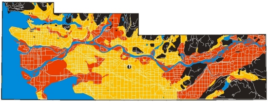
 Moderate
to High (modern lowlands sediments) Moderate
to High (modern lowlands sediments)
 Low
(Ice Age upland sediments) Low
(Ice Age upland sediments)
 Nil
(bedrock) Nil
(bedrock)
This map provides only a generalized interpretation
of liquefaction susceptibility during an earthquake and should
not be used for local geotechnical evaluation.
|